 Ludlow’s town walls date from the 13th century, when they were built to protect the town of Ludlow, Shropshire, Enlgand, from the threat of Welsh attack and civil war. They encompassed parts of the existing town, making use of Ludlow Castle, and included eight gates and at least three mural towers. After the 16th century they fell into decline, and in the 21st century only parts of the circuit and the Broad Gate survive.
History
11th-14th centuries

The Norman lord Walter de Lacy established a castle in the manor of Stanton Lacy soon after the Norman invasion of England in 1066. The settlement, then called Dinham, held a strategic position along the English-Welsh border. Dinham was located on the ridge of a rocky spur, protected on several sides by the River Teme, and may have been further protected by earthwork and timber defences. In the mid-12th century, the town was redesigned around a new plan; the new borough of Ludlow may also have been protected by earthwork and timber defences.
By the early 13th century, the town was controlled by Walter de Lacy. Despite being an increasingly prosperous settlement, the border remained turbulent, and Walter’s had a difficult relationship with King Henry III. Welsh raids in 1228 and 1231 caused considerable damage to the tows of Montgomery, Radnor, Hay-on-Wye and Brecon, and a rebellion against the King by Richard, the Earl of Pembroke, in the autumn of 1233 brought another wave of violence to the region.
Against this background, at the end of 1233, representatives of the town of Ludlow travelled to the royal court at Worcester to seek approval to build new defences. The Crown gave them a grant of murage, allowing Ludlow to raise local taxes to pay for the construction of new town walls. The money raised may not have been initially actually spent on the walls, for reasons that remain unclear, but the urgency of the work was accelerated by the renewed Welsh threat in the 1250s, and, by the end of the 1280s, the construction had been mostly finished: the final developments were concluded by 1304.
The new walls followed a defensible line around the edge of the town, cutting off the more extended suburbs. Although the design tried to respect the existing town roads and burgages, the construction work would have required the demolition of some existing buildings. The town walls had eight main gates controlling access into the inner town: Broadgate, Mill Gate, Dinham Gate, Linney Gate, Corve Gate, Galdeford Gate and Old Gate, and a small gateway alongside the castle. Broadgate had two drum towers, and was protected by a portcullis , and the other larger gates were probably similar in design; Old Gate and Corve Gate also had drawbridges. Mill Gate, Dinham Gate and Linney Gate were probably smaller, however, and may not have had military defences. There were at least three small mural towers along the circuit.
The stone walls were thin and constructed from local grey calcareous siltstone rubble, and as a result were structurally quite weak. They were protected by a ditch that was at least 10 m wide. There was no internal road or path running within the walled circuit, however, which would have made it difficult to defend. The weakness in the walled circuit suggest that their design may have been as much about controlling access to the town as it was for its military defence.
15th-21st centuries

The town corporation took control of the town walls in 1461, and in due course leased out the external ditch for the construction of limepits, gardens and small houses. The gatehouses became used as houses or as commercial properties, and Galdeford Gate became used as a prison, with a tower alongside it. When the antiquarian John Leland visited in the 1540s, he noted that the town was “well waullyd, and by estimation it is about a mile in compas.” The town walls may have been repaired during the English Civil War, between 1642-1646.
By the 1700s, however, the walls were in decay. In 1763, Galdeford Gate and its tower, now ruinous, was demolished and a new gaol built on the site. Old Gate was destroyed in the mid-19th century. A house was built over Broad Gate between the 16th and 18th centuries, and Regency additions built around its west tower in the 1820s. The remains of the walls were renovated at some during the 19th century, with an attempt made to maintain their original appearance using similar building materials.
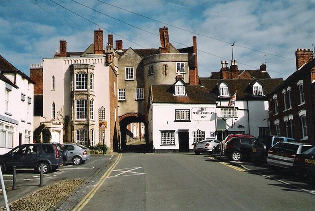
In the 21st century, the only gate to survive is Broad Gate, altered from its medieval appearance. Two mural towers survive, one in the west – heavily altered to become a house, – and one in the east, at Mary Vale House, which retains more of its original features. The circuit survives to the west of Broad Gate, and in fragments along the south side of the town, but retains few medieval features. After a partial collapse of the wall in 2013, the Ludlow Town Walls Trust was established to help preserve them. The walls are protected under UK law as Grade II Listed Buildings and Scheduled Monuments, the Broad Gate as a Grade I Listed Building.
Bibliography
- Creighton, Oliver and Robert Higham. (2005). Medieval Town Walls; An Archaeological and Social History of Urban Defence. Stroud, UK: Tempus. ISBN 0-7524-1445-3.
- Dalwood, Hal. (2005). Archaeological assessment of Ludlow, Shropshire (including Ludford). Worcester, UK: Worcestershire Country Council.
- Halsam, Jeremy. (2016). “The articulation of burgages and streets in early medieval towns, part 1: the case of Bridgnorth, Shropshire”. Landscape History. 37 (1): 51-68.
- Halsam, Jeremy. (2017). “The articulation of burgages and streets in early medieval towns – part 2”. Landscape History. 38 (2): 5-27.
- Irvine, J. T. (1865). Handbook to Ludlow. Ludllow, UK: John Evans. OCLC 56008183.
- Rosenbaum, Michael. (2007). “The building stones of Ludlow: a walk through the town.” Proceedings of the Shropshire Geological Society. 12: 5-38.
- Shoesmith, Ron (2000). “Ludlow Town”. In Shoesmith, Ron; Johnson, Andy. Ludlow Castle: Its History & Buildings. Logaston, UK: Logaston Press. pp. 5–14. ISBN 1-873827-51-2.
- Train, C. J. (1999). The Walls and Gates of Ludlow: Their Origins and Early Days. Ludlow, UK: Ludlow Historical Research Group. ISBN 0-95636113-02.
- Turner, Hilary L. (1971). Town Defences in England and Wales. London, UK: John Baker. ISBN 0-212-98384-9.
- Wright, Thomas. (1852). The History of Ludlow and Its Neighbourhood. Ludlow, UK: B. Jones. OCLC 23929631.
Attribution
The text of this page is licensed under under CC BY-NC 2.0.
Photographs on this page include those drawn from the Geograph and the Yale Centre for British Art websites, as of 18 November 2018, and attributed and licensed as follows: “The Town of Ludlow“, author Fabian Musto, released under CC BY-SA 2.0; “Broadgate and The Wheatsheaf Inn Ludlow“, author Sarah Smith, released under CC BY-SA 2.0; “The South West Prospect of Ludlow Town & Castle” (Public Domain); the plan of the Ludlow town walls, which is based on an underlying map copyright OpenStreetMap contributors, and released under CC BY-SA 2.0.